Highlights from the DSS Collaborative Support Program
Digital Scholarship Services launched the DSS Collaborative Support Program in fall 2020. The program supports faculty with needs ranging from preliminary consultation on project scoping to execution of ambitious collaborative digital projects. All full-time and contingent faculty are eligible. DSS also welcomes proposals from College staff.
During its first semester, the program supported five unique faculty efforts in research and teaching with collaborative support from DSS librarians. Read on for two project highlights. Are you interested in proposing a project? DSS welcomes proposals on a rolling basis. Submit your ideas here.
Seo-Hyun Park, Associate Professor, Government & Law, and Janna Avon, Digital Initiatives Librarian

Screenshot of an interactive map created by students in Dr. Park’s class.
Seo-Hyun Park sought collaborative support for an interactive mapping project in her capstone seminar on Nationalism in World Politics. Whereas in the past Dr. Park relied on lecture slides or maps hung on the wall for a classroom assignment on nationalism and issues of national identity in media coverage worldwide, Janna Avon facilitated a version of Dr. Park’s “Nationalism in the News” briefing assignment using mapping capabilities in the web-publishing platform Scalar. Dr. Park reflects, “Experimental assignments can be exciting but bring with them many uncertainties, and I was pleased to see that this pilot project went very well overall. Having an embedded digital scholarship specialist (in our case, Janna Avon) was crucial. It gave me confidence to move forward with the assignment. The assignment allowed us as a class to organically weave in course materials and class discussions throughout the semester. The visual representation of different “nationalist” events/issues/processes on the class map allowed us to see, compare and contrast similarities and differences in national identity politics around the world. In future semesters, I would like to explore further avenues for extending this assignment (i.e., having students “follow” their event/issue in its various iterations at different points in the semester) and/or incorporating the shared map and narrative function into their final research projects.”
Janna Avon explains, “Scalar is one of several web publishing platforms DSS supports for in class use and personal research. It offers a suite of tools for exploring and illustrating scholarly work, but that same breadth can be overwhelming and prove a barrier to access for someone new to the platform. What I feel is the biggest advantage to partnering with DSS on the use of such platforms is our ability to tailor training on the platform to the user’s specific needs, helping to lower the barrier to access by providing the exact information needed to accomplish the scholarly goals of the user.”
Yusuf Dahl, Bradbury Dyer III ’64 Director for Innovation and Entrepreneurship, and John Clark, Geospatial Services Librarian
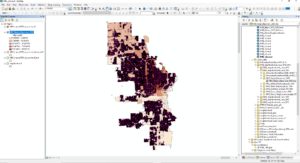
Screenshot of an ArcGIS geodata display representing 133,701 individual property tax assessments overlaid on neighborhood maps which show the percentage of residents who are African American.
For his research on impacts of gentrification on Milwaukee neighborhoods, Yusuf Dahl sought collaborative support from John Clark. Clark explains their methods: “Together we acquired demographic, tax parcel, and inflation datasets from both Milwaukee City and County governments as well as from the US Census Bureau and the Federal Reserve Bank covering 1970 to 2010. I began with over twenty data tables and a half dozen GIS datasets and delivered two sets of five geospatial datasets representing the racial composition and average residential property values for neighborhoods in the City of Milwaukee.” John’s data transformation work allowed them to triangulate demographic data, neighborhood boundaries, and city of Milwaukee property records to explore shifts in racial makeup along with total neighborhood housing values over time. Dr. Dahl reflects, “Partnering with John Clark enabled me to explore more nuanced questions around property assessments/valuations and their effect on resident displacement. Visualizing the relationships in the datasets and changes over time allowed me to express my argument in a more powerful and salient way.”