DSS Supports Exploration in Geospatial Humanities
John Clark, Geospatial Services Librarian. Photo credit: Lafayette Communications
With support from the Lehigh Valley Engaged Humanities Consortium (LVEHC), funded by an Andrew W. Mellon Foundation grant on which Lafayette College Libraries partners, Geospatial Services Librarian John Clark leads a series of exciting initiatives to foster geospatial exploration of Lehigh Valley historical narratives.
In the fall of 2019 he convened the Lehigh Valley Historical Maps Consortium. This group of local archivists, librarians, curators, historians, and others interested in historical maps set a goal to inventory local collections of maps related to the Lehigh Valley. The group meets and communicates regularly about topics related to historic maps and regional history. (If you’d like to join the email list, contact John Clark at clarkjh@lafayette.edu.)
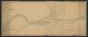
A historic map of the Lehigh River flowing through Bethlehem, PA
One exciting outcome of the Lehigh Valley Historical Maps Consortium is a growing digital collection of historic maps of the region, including the map pictured above of the Lehigh River flowing through Bethlehem. Additionally, for this spring, John has organized a unique workshop opportunity open to all: Past, Place, and Presence in the Lehigh Valley: A Geohumanities Workshop. This virtual workshop will combine expert presentations with hands-on instruction sessions to introduce participants to online tools and methods for finding and working with historic maps illustrating the history of the Lehigh Valley.
Space in this workshop is limited and registration closes on March 19, 2021. Please click here to register for the event. Participants will receive an email confirmation with Zoom login information, and will be paid a $250 stipend for attending.